Saturday, August 1, 2009

August 1, 2009

Potatoes

Went south about an hour to Idaho Falls.  Several objectives.  Jo-Ann’s for some sewing supplies, Sam’s for gas and a few groceries, Walmart for a few more groceries.  Successful on all counts.  Another hour south to Blackfoot.  Objective here was the Potato Museum.  Found it and toured for a half hour or so. 

 01 Patoto Museum

Worlds largest potato ‘crisp’

02 largest Crisp

Bit of trivia.

03 Spud

Actually quite interesting and we learned some things.  Several years ago we drove the entire length of western Idaho and did not see anything resembling a potato plant, only wheat for ever and ever.  Today we learned why.  50% of Idahos potatoes are grown in the southeastern part of the state, 40% are grown in the southcentral part, and only 10% in the southwestern part.  Also, potatoes are rotated with wheat and other crops to replenish the soil.  Today we saw lots of potato fields.

From Blackfoot we headed west to our camp spot in Arco, ID.  Interesting bit of trivia: Arco was the first town in the world to receive electrical power generated by a nuclear reactor.


Friday, July 31, 2009

July 31, 2009

Two National Historic Sites

First stop was only nine miles down the road.  Grant-Kohrs Ranch National Historic Site.  Home ranch of a western cattle empire that once covered more than 1,000,000 acres in four states.  A number of original buildings from 1800’s as well as progression of added structures and updates.  We got there early so we got an tour of the main house.  Huge.  Two story building that with an addition that doubled it’s size has 9000 sq ft of living space.  All the furnishings, lamps, and floor coverings are original.  Where there is traffic the floors and carpets are covered with protective rugs and carpet.   Very nice.  Elegant but still functional. 

03 Dining room, Light fixture-gas, electric and kerosene 01 Grant-Kohrs Ranch House 02 Parlor

We spent two hours wandering all the outbuilding displays and talking to some docents.

07 Chuckwagon

Down the road a way we took a hundred mile side trip on a very pretty road to Big Hole Battle National Battlefield.  Site where Army ambushed a Nez Perce encampment.  Many were killed including women, children, and elderly.  The Indians however fought back and inflicted many casualties on the troops and essentially won the battle.  So great were their losses however that sometime later they were defeated in another battle and forced to surrender.  Not one of our countries shining moments.

Tonight we are in Spencer, ID.  The claim is that the countries largest Opal mine is here.  Have not seen the mine but the opal stuff for sale in the small store is very pricey.


July 30, 2009

Cherries and Batteries

We left West Glacier and headed south along the east side of Flathead Lake.  Flathead Lake is very large (dimensions measured in bunches of miles, several times larger than Lake Tahoe) and offers a wide variety of recreation.  There is one other thing that stands out – cherries.  The conditions of the area must be perfect for growing them.  Every piece of level and not so level ground along the lake has a cherry tree on it it seems.  On the east side that takes some doing as the mountains are almost right next to the lake but if there is some level space there is a cherry orchard.  All of the orchards are small individual family operations.  Cherry stands every mile it seemed.  In one spot we saw three stands on one side of the road and two on the other all within 40 yards of each other, each run by a different family.  The stands are not tents or quickly thrown together sheds.  They are solid buildings that are there for the long haul.

In Missoula we gassed up at Costco and did some shopping.  Then on to Les Schwab to have brakes checked and also batteries.  The house batteries (lights, fans, etc) ran dry at some point and we pretty much cooked them.  Amazingly they still functioned sort of but I knew we were on very borrowed time.  One of the four was marginal.  The other three were totally shot.  We replaced them all.  Now the inverter should work for more than fifteen minutes.  Brakes were fine.

Got out of town and went a bit further south to a nice RV park that says it is on a creek.  That is its’ name – Creekside, but I have not seen a creek yet.  Haven’t looked.


Thursday, July 30, 2009

July 29, 2009

Going to the Sun

We started early and drove straight to the pass, bypassing all interest points for our return trip.

There is one road that goes from one side of Glacier to the other.  It is called ‘Going to the Sun Road’.  One might wonder about the name until you drive it.  The road is 50 miles long from West Portal to East Portal.  There are two long lakes at each end of the road.  Each lake is about ten miles long and the road follows the shoreline of each lake.  Allowing a couple miles transition at the end of each lake that leaves around 24 miles of road to go over Logan Pass. The road starts up and never even levels ‘till it reaches the pass.  The other side is the exact reverse – down constantly.  You go from a forested flat valley to sub-alpine or even alpine meadow and back again.  If you started up the road early in the morning headed east you would literally be ‘going to the sun’.  There is a size limit for vehicles on this stretch.  Twenty one feet long and eight feet wide. Even that is pushing it.  A very narrow road carved into the side of the mountain with a couple of switch backs and a lot of tight turns with wall on one side and nothingness on the other.  Great views!

05 view from  window

Water falls and cascades everywhere.  Mostly water falls because it is so steep.  Will try to get some pictures from Sue.  I was sort of busy on this stretch.  Here’s one.

04 waterfall from tall mtns

At Logan Pass there is a visitor canter.  We got there about 10:15 (they were right about the time to drive there) and the lot was already 3/4 full.  There is a trail that goes a mile and a half uphill to a vista of Hidden Lake.  The first 3/4 mile is on a boardwalk over the meadow.  The rest is steps and stone trail up to the ridge.  The upper part of the trail is pretty strenuous and the elevation gain for the entire trail is pretty substantial.  On the other side it has easy access, a definite objective at the end and does not require taking provisions (back country).  Because of this it is by far the most trafficked trail in the park.  We were there early so it wasn’t too busy.  Coming down we met so many people I had visions of pictures I have seen of the stream of humanity headed over the pass to the gold fields during the Alaska gold rush.

The view at the vista point is outstanding as is every view in the park.

Hidden Lake

One of the objectives when visiting any national park is to see wildlife.  The rangers always tell you the animals are there and even give evening talks on what you might see.  Most of the time you are limited to squirrels and birds.  We had the same hopes on this hike that we have on all our hikes.  On the way up we saw one ground squirrel and a small bird.  We kept scanning the cliffs for mountain goats.  The best we could do was spot an animal trail across a snow bank on the other side of the canyon.  At the overlook I made a light hearted comment about the long hike without even a glimpse of a mountain goat.  The man next to me said “There’s one right over there”.  “Where?”  “Right back there where the trail splits.”   We walked back up the trail about 20 yards and there, less than ten feet off the trail, behind a small tree was – a mountain goat.  Not across a canyon on a cliff, ten feet off the trail behind a tree.


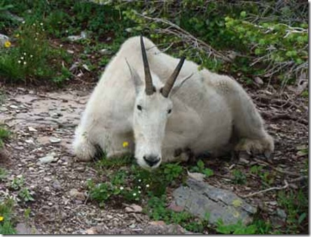
Needless to say that made the whole hike worthwhile. 

About a quarter mile from the visitors center on our way back a man pointed to the edge of the boardwalk.

We looked over the edge and there was a marmot.  Less than three feet away and totally unperturbed by the people walking over it on the walk.


I turned around and about 30 yards away in the meadow on the other side of the boardwalk was this.

White tail buck still in velvet.

On a roll I turned around and looked down the meadow.  Guess what.

Two bighorn sheep about 75 yards away.

We were now only a few yards from the center.  In the greenery along the trail we saw four or five  of these.

Columbian ground squirrels having lunch about five feet from the trail.

It was like a zoo without fences.  Best day we have ever had for wild life.

We went to the eastern border and then back to our campground, sightseeing along the way. Here is a small portion of the lake on the eastern side looking west into Glacier park.  I think the island is called Lone Goose.

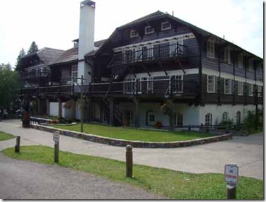
As I have mentioned before, every national park of any size and age has a historic lodge.  Here is one of Glaciers’.


July 28, 2009

Glacier National Park

Got up early and drove to Glacier NP taking the scenic route.  We got to Glacier about 11:00am.  Good thing.  The campground was already nearly full.  We got about the last site that would hold the carbus.  We had lunch and then walked to the nearby village to look at things and get information.  We learned that our planned drive took at least two hours one way and that the visitor center lot at the summit filled early.  The day was sort of cloudy and windy so we decided to stay close to camp and start early tomorrow.  Apgar Village and campground are on the western tip of Lake McDonald.  If the wind is in the right direction it has the entire length of a very long lake to get up steam.  Here is a picture of the lake from neart the campground.

Hare is a little closer view of the distant peaks.

See the mountain face dead center under the white cloud?  The road goes right up the side of that mountain.


Monday, July 27, 2009

July 27, 2009

Route of the Hiawatha

We left at 7:45 for a half hour drive to the Lookout Pass ski area at the summit.  Their summer thing is as home base for the Route of the Hiawatha  bike trail.  They rent bikes, helmets, and lights to those who need them.  Trail passes and shuttle tickets are sold there also.  Rather than describe the trail here I will place a link so you can learn about the trail and its’ history. 

Now that you are enlightened about the trail, here is some of our experience.

This photo is taken from the start of the trail.  Immediately you encounter the East Portal of a nearly two mile long tunnel.

About a half mile in you pass this sign.  If you’re lucky you see it.  It’s dark in there – CAVE dark.  The line down the middle of the sign shows the border between Idaho and Montana.  Idaho is on the left.

About one and a half miles down the tunnel you see this.  Yes, that is the ‘Light at the end of the tunnel’.


Here is the view a little closer to the end.


Just outside the West Portal of the long tunnel is this falls.


One of the trestles we crossed over.

Sue exiting the last tunnel on the route.  Ovel on the left is view in the rearview mirror on my helmet.


Shuttle bus that took us back to near end of long tunnel.  Eight mile bus ride took almost 45 minutes.


Nearly 17 miles (including return back through St. Paul Pass Tunnel), ten tunnels, seven high steel trestles, lots of interpretive and historical information, great weather, and hard to match scenery.  Yes, it was worth hauling our bikes 1000 miles.  :)

Today is Kens’ birthday.  Happy Birthday Ken !


Sunday, July 26, 2009

July 26, 2009

On to Idaho

We drove to Kellogg, Idaho stopping in Spokane for gas.  Kellogg had the closest, least expensive RV park for our plan tomorrow.  Tiny park that is still under construction.  Suited our needs though.  Tomorrow we take a bike ride.