Wednesday, August 19, 2009

August 19, 2009

Scandinavian Heritage Park

Layover day in Minot, ND.  Nice town in the middle of nowhere. (There seem to be a lot of nowheres to be in the middle of) It does have a decent indoor mall anchored by several large stores, large Wal-mart, college, state fair, states’ first winery(started way back in 2002), and TWO Dairy Queens.  Nice place to visit for a short while but I would not want to live here, especially in the winter.

The north central United states have a high population of Scandinavian descent.  Minot has a park dedicated to showcasing elements of Scandinavian history and culture.  There are several buildings, some authentic that have been moved from old country and some replicas.  The most spectacular is the exact replica of a church.  It is all wood construction. There are no nails or screws used.  All joining is with pegs and wedges.  Lots of carving inside and out.  Inside smells like fresh cut wood.

DSC01393 DSC01388 DSC01390 

Sue with new friend at visitor center

DSC01382

Here is the Dala Horse.  The symbol of Sweden.

Dala Horse and Pete


Tuesday, August 18, 2009

August 18,2009

Fort Union Trading Post

Day of driving with one (or two) sights along the way.  Fort Union was not a military post.  It was built by the American Fur Company (established by John Jacob Astor) to do trade with the Native Americans and trappers.  It is located near the confluence of the Missouri and Yellowstone rivers.  A major crossroads for both land and river traffic.   The docent at the fort gave a very good talk about the protocol of trading.  It was not a simple exchange concept.  There was much ceremony and socialization in the process as well.  The fort/trading post is an exact replication of the original built on the original foundations.  The trade room is stocked with trade goods representative of the era which are for sale.  We did not have any hides with us so did not trade.  :)

A couple of pictures.

This is the front gate facing the river.  That small window to the left of the gate is where all trading with commoners took place.  Only special clients were invited in to the trading rooms just inside the gate. 

DSC02924

This area was still separated from the interior of the post by another gate.

DSC02925

Here is a view from the top of the fort wall.  When the fort was built, the Missouri River bank was at the tree line in the front of the picture. A distance of about 30 yards.  Now the river is just in front of that distant tree line.  Several hundred yards away.  The rivers course has changed that much since 1828.

DSC02926   

From the fort/trading post we drove four miles east to the confluence information center.  We had hoped to view the joining of the rivers but the shore line is so overgrown with brush that we could not see anything.

On to Minot, ND.  The ranchers here are very frugal.  :)  They even cut and bale the grass that grows along the highway.


Monday, August 17, 2009

August 17, 2009

Pompey’s Pillar

Our days travel northeast included a ninety mile side trip to Pompey’s Pillar.  This is a sandstone monolith on the banks of the Yellowstone River in east central Montana.  On their return trip from the Pacific, Lewis and Clark split their party for a while in order to explore more territory.  Lewis went north top follow the Missouri and Clark went more south along the Yellowstone.  Clarks party stopped at this spot on their journey.  The Indians had known about this place for centuries, but Clarks’ party may have been the first white men to see it.  Clark named it ‘Pompys Tower’. He named it after Sacajewas’ son who had a very long and very French Canadian name.  Clark called him ‘Little Pomp’.  The name of the landmark got changed by historians who modified things out of ignorance.  (As a grown man ‘Little Pomp’  lived in Auburn for a while during gold rush era. He went by his given name which was still very long and very French Canadian )  For centuries Indians had been scratching pictographs on the sandstone.  Clark scratched his name and date of encampment on the monolith also.  Of all the miles traveled and places seen by the Corps of Discovery,  this is the only remaining trace of their journey.  Needless to say it is well protected from elements and people but is still able to be visited.

Click on picture to see whole thing.

DSC02914 

Here is a duplicate that may be easier to read.  Click on picture to see it all.

DSC02921

Interesting historical note:  Custer and his army camped across the river from this spot days before they journeyed south to the Little Bighorn River.

Local residents:

DSC02907 DSC02908 DSC02909

One more thing.  We now know what ‘Big Sky’ means.  Short of being on the ocean, you can not see more sky at one time than standing in central or eastern Montana and turning 360 degrees.

Here is a picture of last nights sunset. Click on picture to see all of it.

DSC02902


Sunday, August 16, 2009

August 16, 2009

Little Bighorn Battlefield and Crow Powwow

Yesterday we drove from Cody to Billings and beyond.  We took a less direct route to go by the Bighorn Canyon National Recreation Area or at least the visitor center.  Probably the least inspiring we have seen.  Very low key with not very inspiring displays.  We stamped our book and moved on.  In Billings we shopped at Costco and Walmart.  Billings is the largest city in Montana and is busy with traffic.  We got outa town as soon as we were done.  We planned to see Bighorn Battlefield so we drove to Hardin which is the closest town.  As we were checking in to a RV park the manager mentioned that the annual Crow Agency Fair and Powwow was happening now.  We decided to add another night so we could spend some time at the powwow.

Today we went to the ‘fair’ about 9:00am and drove through a sea of teepees.  They were everywhere.  We wondered where the promised morning parade would go.  People were setting up chairs on every road it seemed.  We finally just decided to park in a likely spot and wait.  Turned out we parked on the first turn right after the start of the parade.  This parade is a long progression of Native Americans on horseback followed by those on trucks and floats.  All dressed in their finest native attire.  Some very nice things.

DSC02839 DSC02844 DSC02845

Here is the Fair Princess.  She was throwing candy bars to the crowd.

DSC02841

There were lots of kids.

DSC02851 DSC02855

From the parade we moved down the road a mile to Little Bighorn Battlefield.  We listened to an excellent presentation by a ranger about the events leading up to, including, and after the ‘Last Stand’.  We then watched a video which retold the story graphically.  After that we walked the area to see the actual spots.  The places where each combatant fell have been pretty accurately marked for about all of the soldiers and some of the Indians.

DSC02881 DSC02882 The stone with the black marking is where Custer fell.

The officers who died that day were reinterred in various cemeteries in the east.  The soldiers were eventually buried in a mass grave at the foot of this marker.

DSC02883 

Studying fields of battle is not our thing so we took a last look and headed back to the Powwow which was getting under way.  We walked the rows of trinket and food venders several times and decided to have Indian Tacos for lunch.  The opening ceremonies and dancing got under way in the afternoon.  A couple of pictures from early on.

DSC02891 DSC02892 DSC02893


Friday, August 14, 2009

August 14, 2009

Chief Joseph Scenic Byway and Beartooth All American Road

Day for sightseeing.  These two roads have been called the most scenic drive in America.  They certainly are the most visually stunning I have seen.

DSC02802 DSC02803 DSC02806 See the road snaking down the side of the mountain?  The whole drive was like that, up and down several mountains and over three passes.  The tallest is a little short of 11,000ft.

This bridge is the highest in Wyoming.

DSC02807 DSC02809 Could not get a decent picture that properly shows depth of canyon.  This might give some idea.  It is taken straight down.

DSC02813

Granite Peak, tallest in Montana.

DSC02829

View from Beartooth Pass

DSC02833

Back to Cody.  We spent some more time in the museum complex and then back to RV to do laundry.


August 13, 2009

Cody, WY and Buffalo Bill Historical Center

Left West Yellowstone early so we could get through road control in first wave of the day.  After that it was smooth and scenic road all the way to Cody.  After setting up carbus our objective for the afternoon was the Buffalo Bill Historical Center. 

DSC02789

This is actually five museums in one place (one price too).  Gun museum, Art museum, Native American History museum, Buffalo Bill and Western museum, and Natural History museum.  Each museum by itself is outstanding.  This is from someone who doesn’t do museums.  The Gun museum has over 1500 firearms on display in the main floor and another 1200 on display in a secondary floor (basement).  The Art  museum has art in all media by renowned western artists, much of it owned but some on loan from famous museums (Smithsonian, etc.) Here is one on display now.  It is the size of a wall.

DSC02792

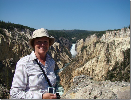
Lower Yellowstone Falls and the Grand Canyon of the Yellowstone.

The Native American Museum shows Indian life and history in a very educational manner.  Large building with many rooms and alcoves each with a different theme.  The portion devoted to Buffalo Bill and western life has many areas devoted to various aspects of life in the early west, especially the cowboy.  There is a lower gallery devoted to artwork depicting the Lewis and Clark Expedition.  In the back of the lower floor there is a research center.  We stopped in and inquired if they had any data on that part of Buffalo Bills life that we have a connection to.  It took them some time and searching but they were able to locate documentation and corroboration.  We left with copies of data and they were happy to meet someone with a tie to BB.

The Natural History museum presentation is done by temperate zones starting with alpine.  One walks down to different level to different displays similar to walking down a mountain.  Very well done.  Even has hands on displays and docents to educate.

The whole thing is placed on grounds that are green and manicured and also filled with exhibits and artwork.

We spent over four hours and were no where near done.


Wednesday, August 12, 2009

August 12, 2009

Yellowstone NP

No entries for the last several days and this will not be too long.  Doing justice to Yellowstone in a blog entry is impossible.  We have been parked in West Yellowstone for three (four?) days.  We have entered and toured the park every day.  Yellowstone is HUGE.  2.2 million acres. That is 3437.5 square miles.  The distances between junctions which are major points of interest are LONG.  We have been out every day and not returned before 7:00pm.  At that point processing photos and writing is not a priority. 

Here is the required picture of Old Faithful.

DSC02749

My view of Old Faithfull Village:  Much like Disneyland.

Both have huge parking areas that are pretty much full.  Both have LOTS of people moving around in what seems like random movement.  Both have an event (parade/eruption) that draws people at a scheduled (semi-scheduled) time.  People start gathering about a half hour early to get good seats.  The event happens and people disperse to their random movement again.

Geyser Village does have Old Faithful Inn.  An historic hotel that is worth a visit.  Great architecture in the style of historic National Park lodges.  Each is unique and indescribable. Here is the outside but the inside is the uniqueness.

DSC02659

A few more pictures.  Here is view from what is called ‘Artists Point’ with good reason.

DSC02732

Proof we were here.

DSC02733

I thought this was fun.

DSC02691

It’s so big it needs its’ own parking lot.

DSC02692

Osprey nest with two fledglings.

DSC02711

Last night we had dinner with friends from Auburn in a Yellowstone campground.  Each of the three couples had been out traveling for some time and our travels managed to come together at a point.  We spent the evening sharing experiences and notes.  I’m afraid that we dominated the evening with our travels.  I apologize for that.  They had wonderful memories and experiences of their own and I wish we had heard more of them.  We will make great efforts to hear more of their travels.  It will take more evenings and more food and wine to hear it all.  Thank you Audrey and Gerry for a nice evening and a chance to experience buffalo meat.  :)

Today we sort of laid back.  Audrey and Gerry had suggested a ‘museum’ in West Yellowstone and we had no need to push on today.

We went to the Grizzly and Wolf Discovery Center.  This is a not-for-profit live museum that showcases wolves and grizzly bears. All animals here have been rescued from situations that meant they could not survive in the wild.   Lots of learning to be had here.  We spent much of the day here.  They have six or seven grizzly bears that they rotate on exhibit often through out the day.  No bear is out more than 1:15 at a time. They also have a kind of junior ranger program.  One part is discussing the bears and how they find food.  When the bears are rotated (don’t ask me how they get the bears to leave the compound but they do) the kids are allowed in to the compound prior to the next bears entering.  Their task is to hide food for the bears to locate.  This assures that the bears are in prime viewing spots for a part of their time out.  Here are kids hiding food.

DSC02760

Here are bears finding it.

DSC02775

There are similar facilities devoted to wolves.
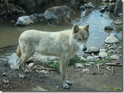
DSC02779

We also watched two movies that took almost two hours about restoration of grizzlies and wolves to Yellowstone.

All in all a nice day without any driving or dealing with crowds.